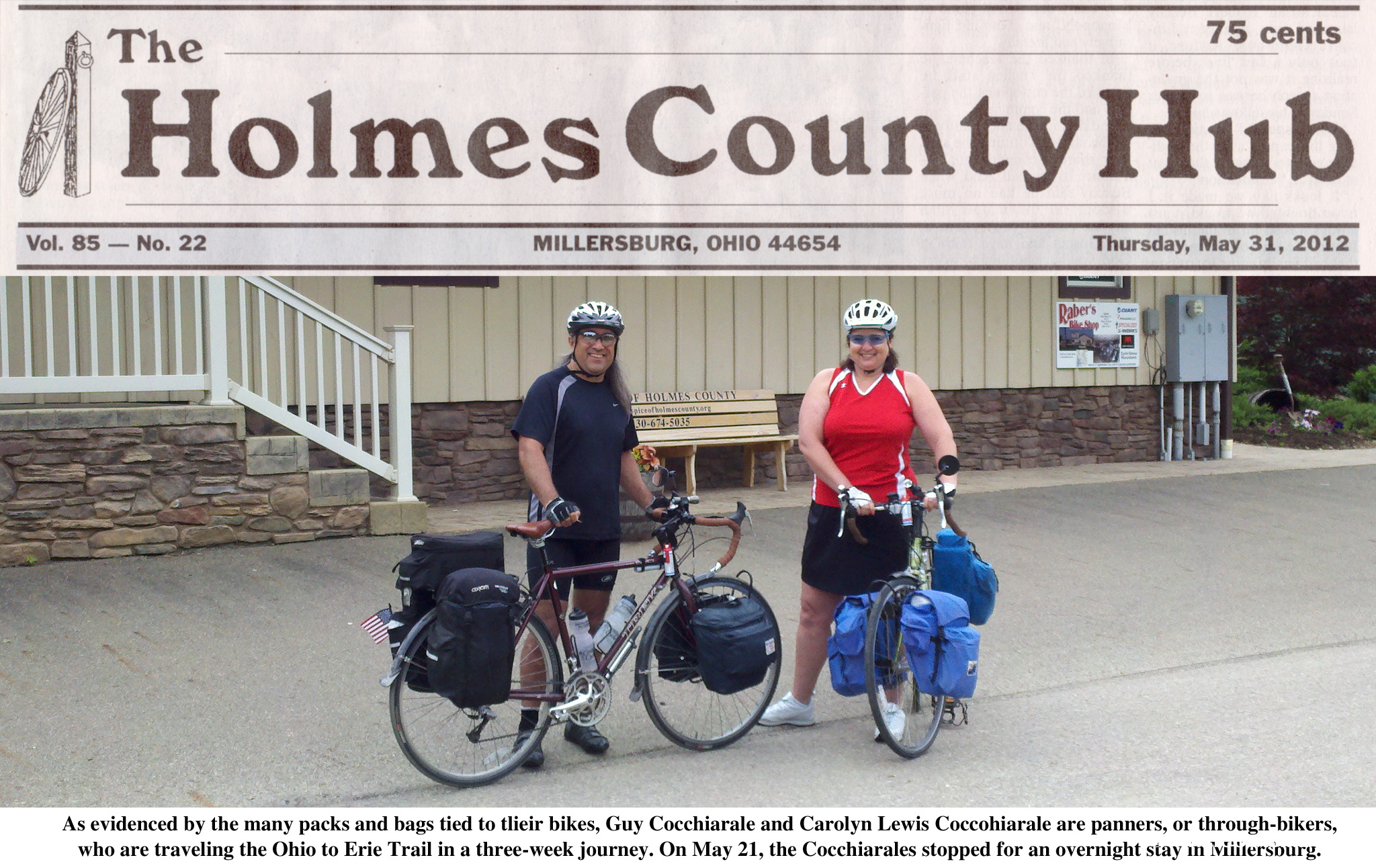
Article in The Holmes County Hub 5/31/12

Bikers put Holmes trail on map

MILLERSBURG — “Up sluggard, and waste not life. In the grave will be sleeping enough.”

This motto, from the inspiring Ben Franklin, has motivated one couple to take a very
different sort of vacation this spring — A riding tour of one of the state’s longest
bike trails.

Husband and Wife duo Guy Cocchiarale and Carolyn Lewis Cocchiarale have embarked
on a tour of the Ohio to Erie Trail, leaving from their home in Cleveland on May 19
to ride the entire length of the trail on a fact-finding expedition.

“We’re trying to raise a ruckus about the trail,” said Guy. “There’s nothing like
walking out of your front door, locking it, getting on your bicycle and that’s it.
There’s no way back home unless you ride.”

And that’s just what they did, locking the door on Saturday to ride the The Ohio to
Erie Trail is an off-road trail stretching from the Ohio River to Lake Erie,
spanning the state from Cleveland to Cincinnati following paths of former railroads
and canals and passing through numerous rural areas, farmlands, nature preserves and
parks.

Along the way, the two stopped for overnight stays in Stowe, Massillon and on
Monday, Millersburg. After a 10.5 hour day of riding, the dusty travelers arrived at
the Hotel Millersburg.

Stopping in Millersburg was determined by one ever-important factor, said Guy.

“It’s determined by places you can stay; You have to go from point A to point C,
going through point B in the middle,” he said, noting that there are several
amenities that make a town rider-friendly.

These include providing safe, dry places to secure bikes, food, water, places to
stay and, he said, beer.

In fact, these amenities will have cyclists using the town as an oasis, he added,
because “you are going through as a different kind of tourist. It’s a subcultural
thing that is injecting money into any local, small economy like this.

The Holmes County Trail offers many perks to this subculture of travelers, said Park
District Director Jen Halverson, noting that the Cocchiarales enjoyed the shade and
smooth, flat surfaces the trail offers.

“They appreciated what we’ve done here,” said Halverson, adding that as more
sections of the trail are finished, even more through-bikers will be drawn to the
area.

“As connections are made between different trail systems, or as more routes become
bike friendly and trail user friendly, I think we’re going to see more people do
this, I think we’re going to see more people coming through this area by this method
of travel as opposed to regular car travel,” she said.

Many of these cyclists are already out on the trail, said Carolyn.

“Since we’ve been on the road since Saturday, we’ve meant six other groups of
through-bikers. It’s a whole different category of people who have different needs,”
she said. For example, “When we arrived in Fredericksburg, we were completely out of
water and we had peanuts to eat. We were desperate. So if you know that there is an
oasis ahead, it gives you momentum … in some of these small towns, you get a
hardware store and a post office and there is no place for food.”

After Millersburg, the two were heading to Mount Vernon, Columbus, London,
Waynesville and, finally, Cincinnati, and back again.

Besides taking an adventurous vacation, the couple plans to accomplish something
with this trip.

Charged with the task of designing an official updated Ohio to Erie Trail map, the
pair also hopes to create an interactive trail guide and mobile app to accompany the
map “so that other people can do what we are doing because a map needs things like
access points, restrooms, places to eat, sleep and rest,” said Carolyn.

The Holmes County Trail, which the two call “the Amish highway,” has the added
benefit of traveling through the heart of Amish Country, where they enjoyed passing
buggies, comparing Amish gardens and biking on a trail that reads “No Horses This
Side” every few miles.

While the Holmes County Trail is unique, the bikers find that each connecting trail
in the Ohio to Erie Trail has something to offer.

“What’s so unique and special about the Ohio to Erie Trail is that it’s combining
all of these different trails and all of these different groups and friends of this
trail and friends of that trail. Just like the Holmes County Trail, there are people
who love it, but all across the state,” said Carolyn. “It’s like the United States,
instead of states you have these county groups and they are all joined together in
this one unique cause to make a greenway from Cleveland to Cincinnati.”

To allow people to follow their progress, the Cocchiarales created a riding blog to
post personal anecdotes and photos from their route.

The name — igotabike.com — invites anyone with a bike to take the trip.

“All you need is a bike.You don’t have to be an athlete, you don’t have to be a pro,
you don’t have to be a billionaire. Anybody can do this. You got a bike, let’s go,”
said Carolyn.

“It’s to let people know how accessible it is, how friendly the people are and how
easy it is to do, and fun. We’re not athletes, we’re just normal people and it’s
doable,” she said. “There is something really fabulous about not turning back. It is
a different mindset. When you are a through-bike, there is this phenomenal sense of
freedom.”

The two aim to return to Millersburg in time for the Rails-To-Trails Benefit Auction
on June 8-9. To follow the Cocchiarales’ progress, go igotabike.com.

Reporter Kelley Mohr can be reached at 330-674-5676 or kmohr@the-daily-record.com.

Reprinted with the author’s permission.

The Holmes County Hub is a weekly Holmes County publication produced by the Wooster Daily Record.
Posted in Press | Tagged , | Comments Off on Article in The Holmes County Hub 5/31/12

Updates as of 6/15/12

Greetings fellow wheelers! We’ve posted some new material that we want to draw you attention to.
there is a great trail loop description for making a two day overnight loop between Cleveland and Stow. It’s an excellent way if you are new to bicycle touring to take a baby step and test your skills and equipment without the commitment of many days and hundreds of miles. You can find it HERE, in our Trail Maps tab.
There is a short review of the wonderful Grunge Brush HERE.
And there is some great information on staying in London, including lodging, food, beer and more right HERE.

Posted in Blog | Tagged | Comments Off on Updates as of 6/15/12

Bike and Hike / Ohio & Erie Canal Towpath Trail Loop: Cleveland to Stow, Overnighter.

NOTE: More information with a 25 mile day trip loop and map that shows the route from the Ohio and Erie Canal Towpath Trail to the Summit County Bike and Hike Trail is located here.

This is a nice loop trail and can be a great introduction to touring with an overnight stay at the approximate halfway point. The entire loop is roughly 70 miles. It is best to follow the Bike and Hike trail south and return on the Ohio and Erie Canal Towpath trail, north. We will start the description from Cleveland, at the Cleveland Metroparks Harvard Road Trail Head, just below the big blue ALCOA plant.

– Head south from the Harvard trail head. In about four miles, you will come to a large visitor center, up the hill on the east side of the trail. You will know you are there when you see the 200 foot high train trestle crossing the valley. There’s a good chance you will see a train there- it’s a pretty busy line. There are latrines down by the trail and restrooms and water at the visitor center.
– In a few miles, the trail crosses over a couple major streets on two really cool (and really expensive!) suspension bridges. Right before the first bridge is a great little resting spot. It’s always shady and there is a kiosk and a large chunk of quarry stone that you can rest on. Across the road is a small park with water and bathrooms.
– A few more miles south and you will come to Rockside road. There is trail head parking and there are several restaurants there. We have eaten at the Yours Truly a few times. Nice atmosphere. Awesome shakes! This is also the northernmost railroad station on the CVSR. From this point south, the trail becomes crushed limestone. You are now in the Cuyahoga Valley National Park.
– About a 1/4 north of Rockside, across Canal road, there are a few other restaurants. We’ve eaten at the Quaker Steak and Lube. No big deal there.
– About four more miles south, you will come to the Canal Visitor Center. There are bathrooms, water and picnic tables, trail head parking and a CVSR station. They also have a working lock there. We have seen it demonstrated and it is really something in its simplicity of design and how fast and efficient it fills and empties. Check with the Visitor Center for hours of operation.


NOTE: There is no water along the Bike and Hike trail. Make sure you fill up here at the Canal Visitor Center!

– Less than a mile south of the visitor center, you will come to Tinkers Creek road. It’s actually along Canal road (the road following the trail). There is a traffic light there and a bridge over the canal from the trail to the road. Cross the bridge to Tinkers Creek road.
– Take Tinkers Creek road east to Dunham road. It is very flat, easy to ride, and traffic is courteous.
– Just before Dunham road, you will see Tinkers Creek Tavern on the right. Good place to eat. We’ve eaten there.
– Turn right (south) onto Dunham road. Astorhurst Golf Course is at the corner. Climb the Dunham road hill. It is very steep, but mercifully short. Traffic can be a little scary here. There’s a gravel driveway at the top where you can safely pull off to catch your breath.
– Follow Dunham road to Alexander road. Along the way, you will see the Metro Parks Bike Path coming down Egbert road on your left and following along Dunham in your direction. It’s such a short distance to Alexander road, that we usually just stay on Dunham, not the trail. Turn right on Alexander, go up a little hill and look for the Bike and Hike Trail Head on your left. There is a latrine. The trail is pretty flat and straight. Great views of the Cuyahoga River valley to the west. This is an abandoned electric railway that ran from Cleveland to Akron, the Akron, Bedford & Cleveland Railroad Co. The ABC road, (or Alphabet Road) ran from 1895 until 1932. Fare was 50 cents and the ride was 2 1/2 hours.


NOTE: There are a few road crossings along the Bike and Hike trail. Many of them have blind turns or hills. Do not take chances! There is one extremely dangerous crossing at Rt. 82 (Aurora rd.). We suggest you dismount and walk across. It’s a four lane 50 mph road. Everything else has a nice bridge going over it.


Note: Just south of RT. 82 (Aurora rd.) you will cross Holzhauer road. There you will see signs for a connector to the Ohio and Erie Canal Towpath Trail, called the Carriage Trail. It is steep, but may be a useful shortcut on another day.

– Brandywine road. The trail used to end here and you would have to take the road. It was dangerous. But no more! The new trail turns right and follows Brandywine road, crossing four wooden bridges before it turns into the woods and runs down hill in a slow, sweeping arc to the left. It gets you rolling pretty fast, so watch for trail users ahead of you. At the bottom are the Scenic Brandywine Falls. They are worth a look if you are not in a hurry. At this point, the new trail goes through a tunnel and comes up at the Brandywine Falls trail head.

20120616-105638.jpg
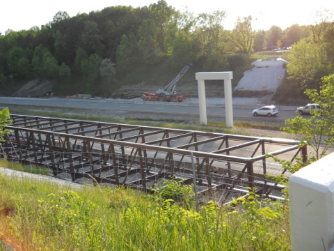
There are bathrooms (composting toilets), but no water, and a nice picnic area. From the trail head, the new trail continues south over I-271. You have to do this stretch on the road, but soon there will be a swell new bicycle bridge! Awesome!

20120616-110622.jpg
Above: the new bridge just before it was installed.

The Inn at Brandywine Falls is a bed and breakfast. We have never stayed there but it looks great and seems worth mentioning. If you’ve been there on bike, drop us a line.
– At RT. 303 there is a trail head and a gas station just a few feet down the road where you can get snacks. Use caution, the trail head path is steep.
– Eventually, you will come to a split in the trail. Take the fork to the right. You will pass through some neighborhoods (still on the trail) and eventually you will come out, paralleling RT. 8 on your right side. You are coming into Stow. This is the approximate half-way point. (The left fork takes you to Kent and Portage County.)
– At Steels Corners road, there will be several hotels and places to eat on both sides of RT. 8. There is a Fridays, Texas Roadhouse, Rocknes and Subway on the east side and a Hampton Inn. We have stayed at the Hampton Inn many times and it is nice, they have a pool. Its great to be able to walk to the restaurants. On the west side there is Brubakers, Skyline Chili, plus Mexican, pizza and Hunan and a Courtyard and Staybridge Suites hotels. We ate at Brubakers. It was OK. Young crowd, bad music, free wifi, close (just a short stroll) to our hotel (Courtyard). The Courtyard ($110) was really nice. Our room had a fridge, microwave and a small balcony. They sell Good Beer by the bottle in the lobby. There are also gas stations on either side of RT. 8 that sell beer. The station on the west side had Good Beer. Don’t remember what the east side had.
– Now you will leave the trail for a few miles and ride west on Steels Corners road. There is a long, gradual climb. Traffic is fast, but the road is wide enough. The traffic thins out pretty quickly, by the time you hit the top of the hill.
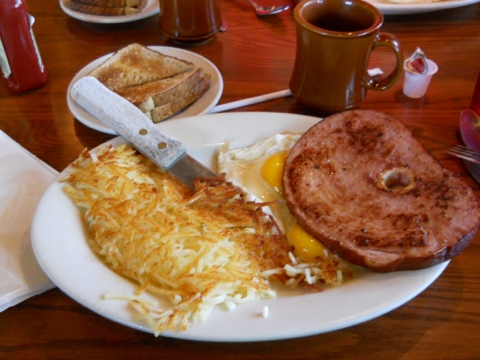
At State street, there is a great mom and pop diner. Reggie’s Diner is to the right (north) on State and will be on the right hand side, just a few feet from Steels Corners. We had breakfast there. I suggest the ham steak and eggs!

20120615-224850.jpg
Anyway, continue down Steels Corners road. It will start going down hill. Very pleasant. You will pass Blossom Music Center on your right (summer home of the Cleveland Orchestra). A little while after that, the downhill starts to get really steep. Be careful! (We’ve hit well over 40 mph here!) There is a stop sign at the bottom! It’s a little ways to the bottom, but if you didn’t know it was there, it has a way of sneaking up on you.
– At the bottom of Steels Corners you will turn left onto Akron Peninsula road. Very quickly, at the stop sign, you will turn right onto West Bath road. Keep an eye open to your left and you will see many nests of Great Blue Heron. West Bath will cross the Cuyahoga River and then Riverview road. After that, you will cross the Ohio and Erie Canal Towpath Trail about 500 feet north of the Botzum Trail Head (latrines, no water). Left on the trail, towards Botzum, heads south, right heads back north. To complete this loop, turn north. You can also catch the Cuyahoga Valley Scenic Railroad (CVSR) north, here at Botzum, and at several other stations along the trail. Fair is only $2 for bicyclists! Check their website for the schedule!
– Here, the trail is crushed limestone. You WILL be cleaning your chain tonight!
– In about 6 or 7 miles, you will come to the town of Peninsula. Peninsula is a fantastic little town along RT. 303 on the Towpath trail. There are several places to eat there. There is a Winking Lizard and our favorite place, Fisher’s Cafe. Fisher’s has a great atmosphere, really awesome burgers and a decent selection of beers. We’ve eaten there often. There is also a Century Cycles there. You can rent bikes from them, get repairs, buy a bike, get water, or just hang out. The CVSR also stops in Peninsula.
– North of Peninsula a few miles is the little town of Boston. There is a very small store (We’ve never been in it), a really nice small canal boat museum/visitor center and water and restrooms.
– About a mile or so north of Boston is the Youth Hostel, the Stanford House. It’s down a mysterious dirt road off the east side of the trail. There is also overnight camping there. We have never stayed there. Yet.
– North of Tinker’s Creek road will be the Canal Visitor Center. There are bathrooms, water and picnic tables, trail head parking and a CVSR station. They also have a working lock there. We have seen it demonstrated and it is really something in its simplicity of design and how fast and efficient it fills and empties. Check with the Visitor Center for hours of operation.
– About four miles north of the Canal Visitor Center is Rockside road. There is trail head parking and there are several restaurants there. We have eaten at the Yours Truly a few times. Nice atmosphere. Awesome shakes! This is also the northernmost railroad station on the CVSR. From this point north, the trail again becomes paved.
– About a 1/4 north of Rockside, across Canal road, there are a few other restaurants. We’ve eaten at the Quaker Steak and Lube . No big deal there.
– About a mile, or less, north of Rockside, the trail crosses over a couple major streets on two really cool (and really expensive!) suspension bridges. North of the second bridge is a great little resting spot. It’s always shady and there is a large chunk of quarry stone that you can rest on. Across the road is a small park with water and bathrooms.
– The trail rolls north about four miles to another very large visitor center, up the hill on the east side of the trail. You will know you are there when you see the 200 foot high train trestle crossing the valley. There’s a good chance you will see a train there- it’s a pretty busy line. There are bathrooms down by the trail.
– A couple more miles north and you will be at the Harvard road trail head. This is ostensibly the end of the trail. You are just a few short miles from downtown Cleveland. The trail now becomes a bike route. Turn left out of the parking lot. Cross the small bridge over the Cuyahoga River. Cross the tracks and turn right at the light. The trail proceeds north from there, on Jennings road, passing behind Steel Yard Commons, a sprawling retail center.

Posted in Trail Maps | Tagged , | 1 Comment

The Grunge Brush chain cleaner

The Grunge Brush by Finish Line
Price Paid: $15 +/-
Grade: A
Link: www.finishlineusa.com/products/grunge-brush

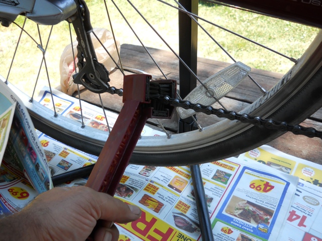
The Grunge Brush by Finish Line is a really simple but useful tool. Carol saw it and bought it before the guy at the bike shop could even tell her about it. If you ride the limestone canal bike trails, you absolutely need to clean you chain and drive train on a regular basis. We took ours on our Ohio to Erie trail tour because a lot of t hat trail is limestone, dirt, or worse. It’s super easy to use; just dip it in some of your favorite degreaser, hold it so the chain runs through the brushes and turn the crank arm.

20120614-182141.jpg
You can easily get several different angles on the chain to get it thoroughly clean. At the butt end of the tool are some longer, thinner, stiffer bristles for cleaning the chain rings, cassette and idler gears.
This thing works great and is light weight. We used to use the clamp on style cleaner with the little fluid reservoir at the bottom. That thing was fussy, had moving parts and used too much degreaser. This works way better.
By the way, my degreaser of choice is plain old gasoline. I’ve tried lots of other stuff, but nothing beats gas. Just my two cents!
Oh, one more thing… when you’re cleaning your chain, lay some old newspapers down, its gonna splatter!

Posted in Gear Reviews | Tagged | Comments Off on The Grunge Brush chain cleaner

Lodging in London

Review of London

London, Ohio, is bike crazy, driven by The Friends of Madison County. Wayne Roberts and Gene Pass, of Roberts Pass fame, are two of their biggest proponents. The trail volunteers, business owners and local government work together in a way not seen in any other town along the trail. Their understanding and appreciation of the Ohio to Erie trail as part of their economy should be a model to all. In our brief stay in London, we visited many of the businesses there. Look for them and others on the signs at trailheads.

Where to stay.
We stayed at Alexandra’s Bed & Breakfast. Twice. It’s a very nice B&B filled with great antiques, run by Ron and Susan. The really cool thing for bikers, however, is the hostel they built in the carriage house! Inside, there are about ten or twelve bunks. Each bunk comes with a plastic tub that contains your sheets, blankets, pillow, towel and robe. There is a shared bathroom and showers. There is also laundry! Your bike is secured in a locked garage area. You have 24 hour access to your bunk and bike with a secure door code keypad. All that at just $25 a night. Oh, and free wifi, too.

There are also hotel/motels out Rt.42 at I-70, out by the truck stops. We stayed once on a previous tour at the Holiday Inn Express, iirc. Nice room with a fridge. There’s also a Motel 6 and also a Walmart and other retail stores out that way.

Where to eat.
Two great places that we tried. The first is the London Coffee Peddler. Mike is an avid cyclist and will talk bikes with you all day long. Check the link for his hours and menu. Right around the corner from Alexandra’s.
The other place we ate at (twice), was Rothwell’s. Scott Rothwell is the owner and is one of the local business people that understands the importance of the trail to London. He’s got a great menu, excellent beer selection, and a pretty extensive wine selection from what I could see (remember, I’m a beer drinker :) The cornbread is so sweet and melts in your mouth. Oh, and I really dig the sour kraut balls. We had them both times we were there! Rothwell’s is maybe about a mile’s stroll from Alexandra’s.
Other things to note.
There is a good laundromat on High St. Just past The London Peddler, just over the tracks. Throw your clothes in, then go back and hang out with Mike while your waiting on the spin cycle.
The trailhead on the south side of town is awesome. There is a huge picnic shelter, running water and real flush toilets.
London is a pretty big town. There’s a giant Walmart in a large retail area on the outskirts. There’s a Family Dollar, a Kroger, and a Save A Lot, Kmart and CVS in town.
There is no bicycle shop!

Posted in Lodging | Tagged | 3 Comments

I Got A Bike in Cincinnati’s City Beat Magazine

Check out this great article in the Cincinnati City Beat Magazine, On the Trail of Dreams by Stephen Carter-Novatni. It’s about our bicycle adventure touring the Ohio to Erie trail. It talks about the trail, our blog and trail guide and the new map Carol is designing for the trail, commissioned by Jerry Rampelt, Executive Director of the trail.

Posted in Blog | Tagged , | Comments Off on I Got A Bike in Cincinnati’s City Beat Magazine

Personal Safety Equipment

Common Sense. I know it’s not so common these days, but a little bit still goes a long way!

While it’s not exactly etiquette, I’d like to talk about gear. Let’s start at the top – your helmet. You do have one, don’t you? Your helmet can save your life, or even more importantly, it can make the difference between living a normal life or living as a vegetable. We won’t ride to the corner without our helmets. We have personally witnessed several bicycle accidents where the helmet was the deciding factor in a happy or unhappy ending. The most recent was a woman just tooling along down the Holmes County trail when he caught a small buggy rut and it flipped her bike. She landed hard on her head, but was able to joke about it with the EMS crew because she was wearing a helmet. It was just a tiny rut in the trail and she was going slow and she saw it coming, and she still wound up on her head!
Get a helmet. Wear it.
Now, just because you’ve got a helmet on your noggin doesn’t mean it will save you. You need to have the chin strap buckled. And tightly! I can’t tell you how many people we’ve seen with a helmet on, but unbuckled or loose, wearing it like a derby. What’s gonna happen the second you hit something hard enough to throw you from your bike? Just as you and your bike shall part ways, so shall ye and ye helmet.
Splat.
One of the most grievous scenarios that we witness is the parents with their children, either in a trailer, tag-a-long or their own bikes. The kid has a helmet, but the parent doesn’t.
What’s that teach the kid?
Now, I’m not the Bubble Wrap Police. I don’t think children need to wear a helmet just tooling up and down the sidewalk everyday, just playing with their friends. The fact is, kids bounce way better than adults. And adults have a longer distance between their heads and the ground. That equals more velocity. When cycling with your kids, set an example, wear a helmet. Besides, do you want them to grow up with out a parent because you were too cool to wear a helmet? Or even better, picture them spoon feeding you applesauce because you are at the cognitive level of a rutabaga.
Seriously.
Gloves. A little less dramatic here. Get some gloves. They can greatly reduce hand pain and fatigue because they are padded. And if you do happen to go over the bars, they can save you the pain of skin grafts and picking towpath limestone out of your palms for the next month and a half.
Eyewear. Protect your eyes. Even a wayward Junebug at 20mph is gonna feel like a bus. We use inexpensive safety glasses. You can get them tinted and in special sizes that can go over regular glasses.
Footwear. I see people wearing sandals. More power to ’em. To me, there are too many moving parts to a bicycle and way too many road hazards. I wear bicycling shoes. Plus, bike shoes are generally stiffer than regular shoes or tennis shoes. The stiffer the shoe, the more efficient your stroke. That’s what she said 😉
While I’m at it, for those who are wondering what the obsession is with spandex shorts, those shorts have built in padding. They help you to ride longer and with less friction because they are tight. Oh, and we don’t wear underwear either. Seriously. Less friction. Also, baby powder, Shea butter, diaper rash cream, all allies against friction and pain.
So the next time that you see a cyclist and think he’s just a goofball that dresses funny, know that he’s a goofball that dresses funny for a reason!

Posted in Etiquette/Safety | Tagged | Comments Off on Personal Safety Equipment

Lodging in Massillon

Review of Massillon
The place to stay in Massillon is the Hampton Inn. We have stayed there at least three times and it is very convenient to the trails. It is only one block from the Sippo Valley and Towpath trails. The staff is friendly and accommodating and they LOVE bicyclists!
Every room has a fridge and a microwave. Bikes are allowed in rooms. Rooms are in the $120 range.
Other things to note:
– Free Breakfast
– Free wifi
– No pool at hotel, but the Massillon Rec Center is five blocks north.
It is Free for hotel guests and has multiple pools, including a lap pool.
– No Laundry
– One block from trail
– Drug and grocery stores one block
– Fast food, BW3, Rockne’s…
There is a drive through beer store across the bridge. It’s within walking distance. Less than a half mile.
There is a liquor store across Erie street, just across from hotel garage entrance.
Click the link below to book your room now!

We’ve had good food at both of these places very near the hotel:
Kozmo’s Grille
Right across the street from the hotel. Has a bar and really good food. Click their ad below!

Smiley’s Ristorante & Pizzeria
– One minute walk
– Italian New York style
– Beer
– Good carry out

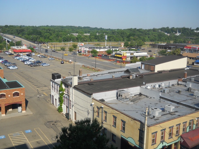
Picture from our Hampton Inn hotel room window, looking west, shows trails, stores, and fast food. The Towpath trail is running horizontally just below the trees in the background. The bridge on the left leads over to the Sippo Valley trail and the drive thru. The parking lot in the foreground has the BW3 and Rockne’s. Across the street is McDonalds, the grocery store, Rite Aid. The yellow brick building in the foreground is Kozmo’s Grille.

20120611-132056.jpg

Posted in Lodging | Tagged | Comments Off on Lodging in Massillon

Lodging in Millersburg

In Millersburg, along The Holmes County Trail, you have basically two choices for accommodations. We stayed at both.
The first, most obvious choice, is the historic Hotel Millersburg right in the center of downtown. Rooms are in the $120 per night range. The hotel is beautiful and is brimming with antiques. Our room had an antique bed, nightstands, lamps, chairs and armoire. Our room, as well as all the hallway walls were covered in vintage photos, paintings and prints. It really was remarkable. If you are visiting Millersburg to go antiquing, this is the place to stay. Because of all of the antiques, however, we were not allowed to bring our bikes to our room. It’s understandable, but you need to know this ahead of time. They let us lock them up outside in the courtyard by day and at night they were locked up in the banquet room. I’m not sure if this is always their standard procedure, so call ahead if you are planning to stay here.
Other important notes about the Hotel Millersburg:
Free Wi Fi
No pool
No laundry
No breakfast
No bikes in rooms
No fridge or microwave
There is a tavern and restaurant.

The other choice of lodging is the Comfort Inn, less than a mile away and right off the trail. It’s right by the WalMart but on the other side of the road. Look for the Glen Drive Business District sign along the trail, between the WalMart to the south and the Millersburg Station trail head to the north. Follow the path up to the road and the hotel is on the other side, through the traffic light. The light may not respond to your bicycle.
Rooms are in the $120 range and are equipped with a fridge and a microwave. The hotel is exceptionally clean. Our bikes were allowed in our room. A cool feature of this hotel is its salt water pool and jacuzzi! We usually steer clear of the indoor hotel pool/jacuzzi scene, but this was too awesome to pass up. It really soothed our sore and tired muscles. Great feature.
Other items to note:
Free Wi Fi
Laundry room (also, a laundromat next door)
Free breakfast (real eggs and sausage)
Close to trail, WalMart, fast food (BK, Subway, more)

Other things to note about Millersburg:
– It seems most of the pizza joints close fairly early, even on weekends.
– We had breakfast at a great coffee shop, Jitters, across from WalMart. Free wifi, really good food.
– Liquor and good beer can be had at Millersburg Ice. It’s right on the edge of downtown, overlooking the trail.

Posted in Lodging | Tagged | Comments Off on Lodging in Millersburg

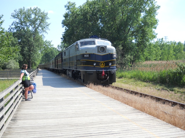
Final Gratuitous Train Pic

20120611-110806.jpg

Posted in Blog | Tagged , | Comments Off on Final Gratuitous Train Pic