April Fools Day, Let’s Ride

Welcome to April Fools day and the start of our Official Cycling Season here at IGotABike! Carolyn and I are both really excited about this season. Last year was awesome, as we logged just about two thousand miles. Hopefully we can do that much (or more) again this year. We are again planning to ride the entire Ohio to Erie Trail this spring (round trip). We hope to see all of our old friends and even make some new ones along the way. We will post trail updates and blogs as we pedal.
From what we have heard, there are a few improvements to the trail this year. We heard from one of our readers, djroseman, that “the detour for the Olentangy Trail as part of the Ohio to Erie Trail around the Dodridge bridge in Columbus is no longer applicable. The rebuilt bridge along with underpass is now open.”
Yay!
He also said that many other small gaps in the trail have also been filled.
There are also additions to the Heart of Ohio Trail. There are many more trail extensions that will open in the summer of 2013. Stay tuned for our updated maps and pictures after we ride through them.
 Right now our main focus is getting our bikes and our butts in shape enough to make the ride. It’s still plenty chilly here in Cleveland with temps this week in the mid 30s with a constant and gusting wind ripping across Lake Erie. Even so, it was nice enough for us to get in a short ride this past Saturday.
Gear-wise this year, we are thinking about trying new tires- something a touch bigger. Carolyn wants new bar tape and padding and I want new bars- something flatter on top and more shallow of a drop, and maybe with a slight rise. Here’s a GREAT site on choosing bars: The FSA Compact is looking tempting. Or maybe the Nitto Randonneur.
It’s enough to make me lose my mind

Posted in Blog | Comments Off on April Fools Day, Let’s Ride

New information on The Ohio To Erie Trail through Columbus

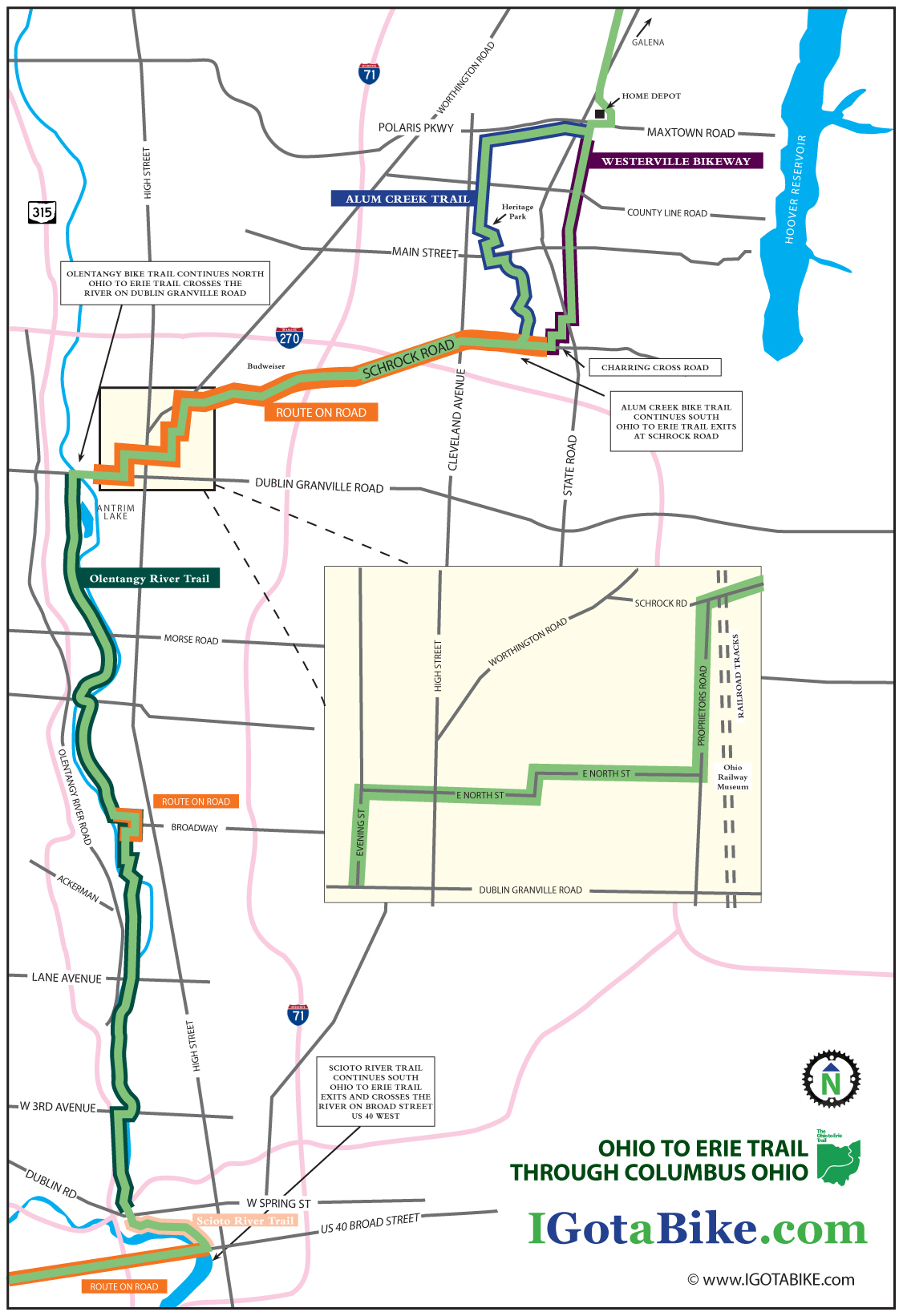
Trail descriptions, a map, and way-finding photos for both the north to south, and the south to north route through Columbus have been posted on the trail maps page. Thanks to all who motivated me to add the south to north description, it came out nice. You were right, we needed to describe the route in both directions.
So, now that all that work describing the route has been completed, in both directions, and you fully understand it, and are thinking about riding it…it is all going to change. Ha! But it is a change for the better. More trail and less road!
I have been told that work is currently underway to extend the Alum Creek Trail to provide access to downtown Columbus and it will eliminate the on-road route along Schrock Road. Stay tuned to see if it opens later this summer.

Posted in Blog | Comments Off on New information on The Ohio To Erie Trail through Columbus

Ohio To Erie Trail Through Columbus with map, south to north

The Ohio To Erie Trail through Columbus is fairly easy to navigate going south to north. From US 40 / Broad Street you pick up the The Scioto River Trail in downtown Columbus and then follow the Olentangy Trail north to Dublin Granville Road where the route switches to on-road and follows Schrock Road east. Then it is riders choice to use the bike trail that goes through Alum Creek Park or the bike trail that goes through Westerville. The road riding is a bit difficult in spots and finding the next turn can be tricky but it is overall a very nice route considering the challenges of urban riding. It is approximately 25 miles.

UPDATE February 2014: New section south of Columbus via the Scioto Trail

Until late 2013 the Ohio To Erie Trail used the Broad Street Bridge at Marconi. The new route follows the Scioto Trail west of Columbus. This new section is made possible by the  bridges that cross the Scioto River 3 times. This new route eliminates several miles of road riding on US 40 Broad Street between Marconi and Westgate. The recommended road route is illustrated on Map 3, Panels  3, 4 & 5 of the Ohio To Erie Trail Printed Maps. You still need to use US 40 Broad Street to get under Interstate 270.

UPDATE April 2013: The Olentangy Trail detour between Lane Avenue and Dodridge is over. The Olentangy Trail is now contiguous through the Ohio State University campus.

For the north to south route click here.

US 40 / Broad Street to Dublin Granville Road via The Scioto River Trail and The Olentangy Trail (approx 11 miles)
Traveling east on US 40 / Broad Street you will come into downtown Columbus and will need to pick up the Scioto River Trail north. Look for a giant museum called COSI on your right and a replica of the Santa Maria down below the bridge on your left. This is where you turn left to head north on the Scioto River Trail immediately after crossing the river at the north west corner of Broad Street and Marconi Blvd. The trail begins in a park just above the ship and heads north with the river on your left.
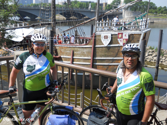
The replica of the ship Santa Maria is your landmark for the spot where you exit US 40 / Broad Street and turn left after crossing the bridge to pick up the Scioto River Trail. The bridge in the background of this photo is US 40 / Broad Street.

The replica of the ship Santa Maria is your landmark for the spot where you exit US 40 / Broad Street and turn left after crossing the bridge to pick up the Scioto River Trail. The bridge in the background of this photo is US 40 / Broad Street.

It is just one mile to the intersection with The Olentangy Trail where you turn right and cross Dublin Road / W Spring Street to continue north on The Olentangy Trail. There is a giant boating club just as you approach the interchange.
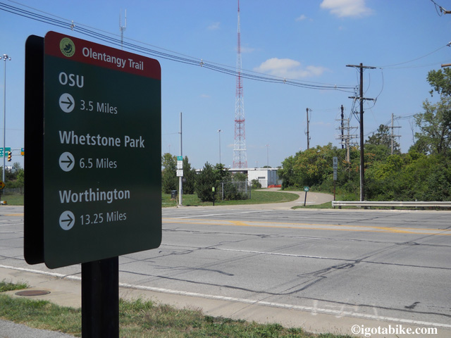
There is a sign at the intersection of the Scioto River Trail and The Olantangy Trail.

There is a sign at the intersection of the Scioto River Trail and The Olentangy Trail. This view is looking north.

There is a sign at the intersection of the Scioto River Trail and The Olentangy Trail. This is where you turn right to leave the Scioto River Trail and continue north on The Olentangy Trail. (NOTE to through cyclist from far away: OSU is Ohio State University, Whetstone is a local park and Worthington is a suburb to the north where you will turn to follow Dublin Granville Road.)

The Olentangy Trail is fairly well signed and has a yellow dashed line down the center that will help to keep you on course as there are many side spurs and connectors that do not have the painted dash lines.
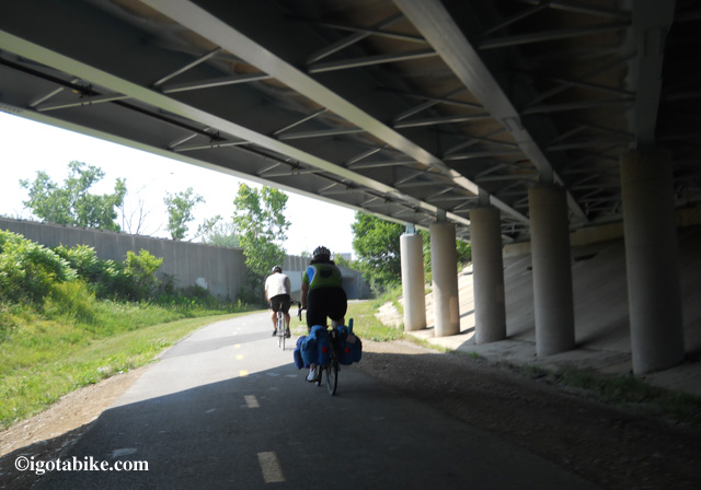
The Olantangy Trail has a yellow dashed line down the center that will help to keep you on course as there are many side spurs and connectors that do not have the painted dash lines. Follow the yellow dashed line.

The Olentangy Trail has a yellow dashed line down the center that will help to keep you on course as there are many side spurs and connectors that do not have the painted dash lines. Follow the yellow dashed line.

(note: this is actually a southbound photo from day 5 of our 3-week long 2012 tour with our buddy Scott leading the way) Its a nice shot of the dotted line.
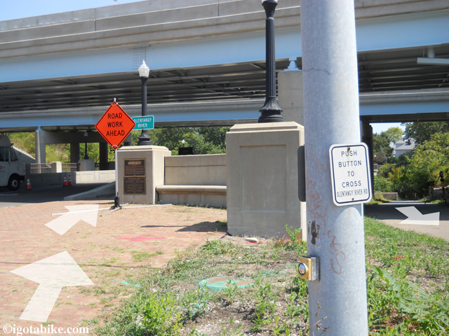
“Gopher holes” go under the bridge to access the trail from either West Third Avenue. Continue north with the river on your left.
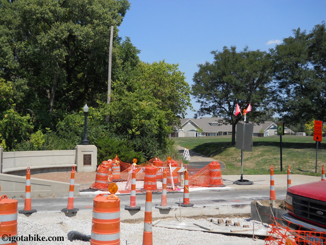
“Gopher holes” go under the bridge to access the trail from either West Third Avenue. Continue north with the river on your left.

In August 2012 the bridge crossing West Third Avenue along the Olantangy Trail was under contruction. Continue north following the detour around the block, and after construction continue through the tiny Harrison North Park pictured here.

In August 2012 the bridge crossing West Third Avenue along the Olentangy Trail was under construction. Continue north following the detour around the block, and after construction continue through the tiny Harrison North Park pictured here.

UPDATE APRIL 2013: The detour described below has ended. The Olentangy Trail is now contiguous through the Ohio State University campus. Use the detour route if you want to experience Buckeye country.

At Lane Avenue The Olentangy Trail is detoured and you will make a hairpin turn to the right to go up to the road and turn right to cross the suspension bridge.
Use the crosswalk to cross Olentangy River Road and turn right and follow the sidewalk in front of the Schottenstein Center.
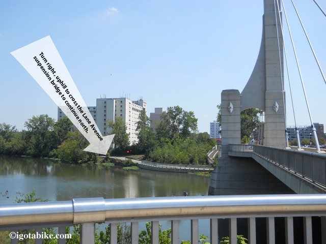
The Olantangy Trail is detoured, turn to the right to go up to Lane Avenue and turn right to cross the suspension bridge. You will be in front of the Schottenstein Center.
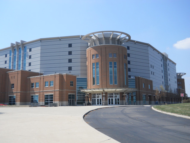
The Olentangy Trail is detoured, turn to the right to go up to Lane Avenue and turn right to cross the suspension bridge. You will be in front of the Schottenstein Center.

The Schottenstein Center is the landmark for navigating the Olantangy Trail detour through the Ohio State University campus. The detour follows Olantangy River Road on the west side of the street between Lane Avenue and Ackerman Road.

The Schottenstein Center is the landmark for navigating the Olentangy Trail detour between Lane Avenue and Ackerman Road.

The Schottenstein Center is the landmark for navigating the Olentangy Trail detour through the Ohio State University campus. The detour follows Olentangy River Road on the west side of the street between Lane Avenue and Ackerman Road.
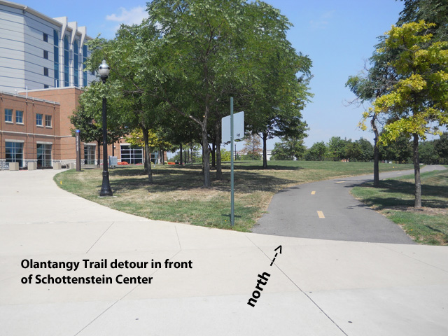
The detour follows Olantangy River Road on the west side of the street in front The Schottenstein Center.

Follow the detour signs as the trail appears and re-appears and as it utilizes sidewalks along Olentangy River Road and passes in front of the Jack Nicklaus Museum.
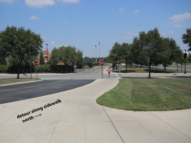
The trail will take you back across Olentangy River Road at the intersection of Ackerman and you will be on W Dodrige Street, facing traffic, behind a temporary concrete wall for 500 feet and you will turn left into Schiermeier Olentangy River Wetland.
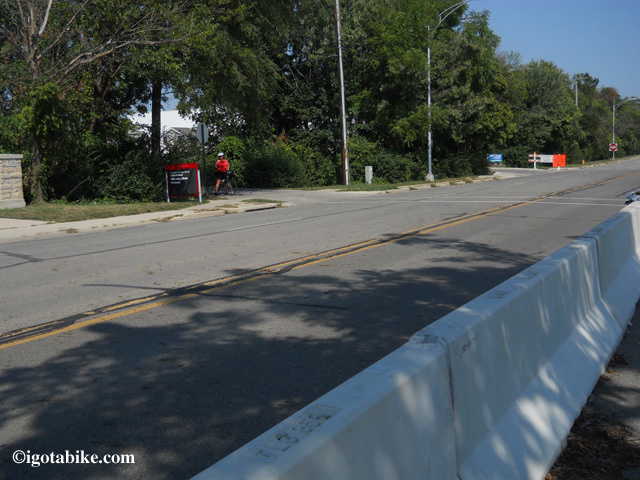
Following the detour along W Dodrige Street, you will be behind a temporary concrete wall for 500 feet and you will turn left into Schiermeier Olentangy River Wetland.

Following the detour along W Dodrige Street, you will be behind a temporary concrete wall for 500 feet and you will turn left into Schiermeier Olentangy River Wetland.

As the trail continues north it utilizes the road for a short distance through the Clintonville neighborhood. (It is a nice area with beautiful homes and gardens.) It is well signed, easy to navigate and approximately 1 mile. (At the intersection of Riverside and W Como Avenue the trail dead ends and follows Riverside Drive – turn right on Delhi – turn left on Milton – turn left on W Kenworth which turns into Olentangy Blvd – turn left on Northmoor  and the route becomes trail again as Northmoor dead ends into Northmoor Park)
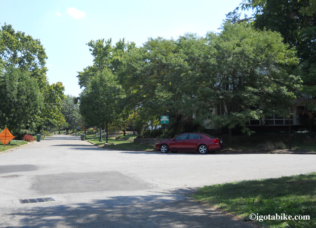
No worries as the trail is well signed as it continues north and utilizes the road for a short distance through the Clintonville neighborhood full of beautiful homes and gardens. Your only worry will be trying to figure out why you don’t live here, right on the trail!
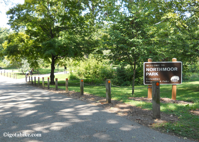
No worries as the trail is well signed as it continues north and utilizes the road for a short distance through the Clintonville neighborhood full of beautiful homes and gardens. Your only worry will be trying to figure out why you don’t live here, right on the trail!

The route becomes trail again as Northmoor dead ends into Northmoor Park.

The route becomes trail again as Northmoor dead ends into Northmoor Park.

The route becomes trail again as Northmoor dead ends into Northmoor  Park. There are picnic tables just ahead and a drinking fountain coming up at Antrim Lake.

Just after passing through the Park of Roses and Whetstone Park the trail follows the road to cross the river at W Henderson Road and continues north with the river on your right. There is hairpin blind turn and a fish-eye-mirror mounted on a tree to aid your view. Use caution here.
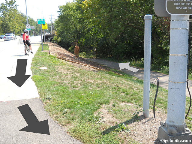
In a now familiar fashion the Olantangy Trail exits the treeline to follow the road-side trail to cross the bridge over the Olantangy River and contininue north. In this photo Carol is facing south. The arrows point north.

In a now familiar fashion the Olentangy Trail exits the treeline to follow the road-side trail to cross the bridge over the Olentangy River and continue north. In this photo Carol is facing south. The arrows point north.

There is a drinking fountain along the trail in Antrim Park. The trail exits the woods and travels along-side a chain link fence that parallels Route 315.

When the trail arrives at the intersection of Dublin Granville Road turn right and cross the river using the Dublin Granville Road bridge and proceed on the trail that parallels Dublin Granville Road.
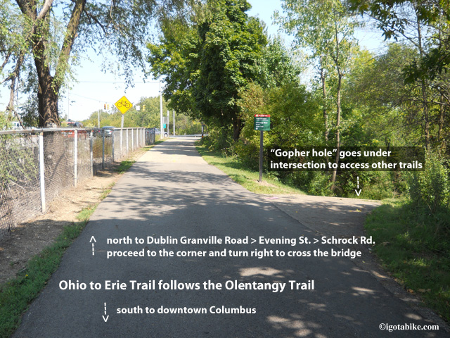
To follow the Ohio to Erie Trail north ignore the “gopher holes” that take you under the intersection of 315 and Dublin Granville Road. Turn right and cross the bridge on Dublin Granville Road.

THE OLENTANGY TRAIL AT DUBLIN GRANVILLE ROAD TO WESTERVILLE
Just across the Dublin Granville Road bridge you will follow the trail as it dead ends into a neighborhood street that parallels Dublin Granville Road. (Ignore the bike trail that is a 180° hairpin right turn that goes under the bridge and goes north.) Continue forward to head east to continue the northbound route of the Ohio to Erie Trail.
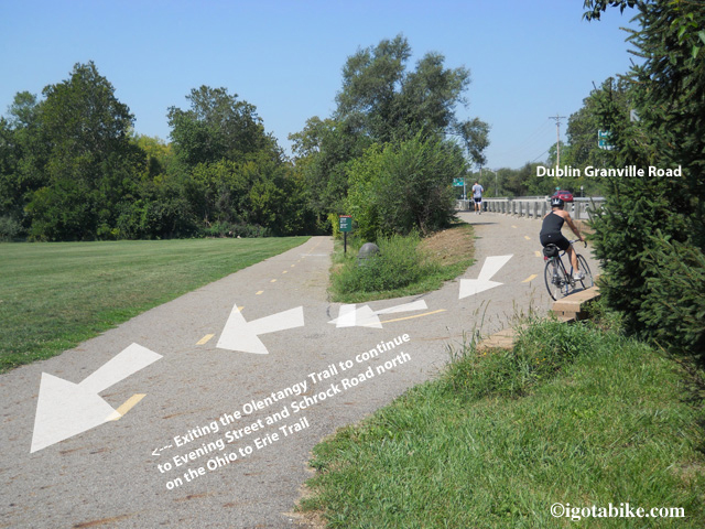
Just across the Dublin Granville Road bridge you will veer downhill and follow the trail as it dead ends into a neighborhood street that parallels Dublin Granville Road. Ignore the hairpin turn.

Follow this little side street up to the traffic light and turn left onto Evening Street. Turn right on E North. You will cross High Street.  Turn left at Pingree to stay on E North and follow it until it dead ends at Proprietors Road, turn left. You will see the Ohio Railway Museum  at the intersection of E North and Proprietors Road.
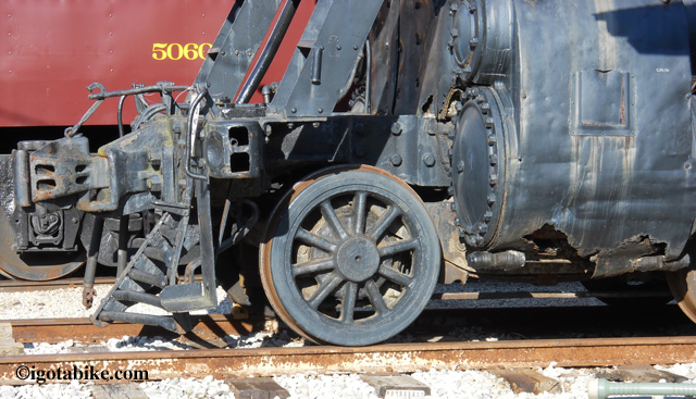
You can’t miss seeing the the Ohio Railway Museum at the intersection of E North and Proprietors Road where you will turn left to get to Schrock Road.

You can’t miss seeing the the Ohio Railway Museum at the intersection of E North and Proprietors Road where you will turn left to get to Schrock Road.

Follow Proprietors Road until it dead ends at Schrock Road where you turn right and cross the railroad tracks. Follow Schrock Road past the Budweiser plant. You will go over Interstate 71 and over Interstate 270. You are now approaching the place to choose to use the bike trail that goes through Alum Creek Park or the bike trail that goes through Westerville. We rode both and they are equal in distance and both are pleasant.

ALUM CREEK TRAIL:
To use the Alum Creek Trail you will access the trail at the Schrock Road bridge that crosses Alum Creek. Just past the bridge turn right onto the trail and use caution as it makes a right hand hairpin turn to go under the bridge and continue north.
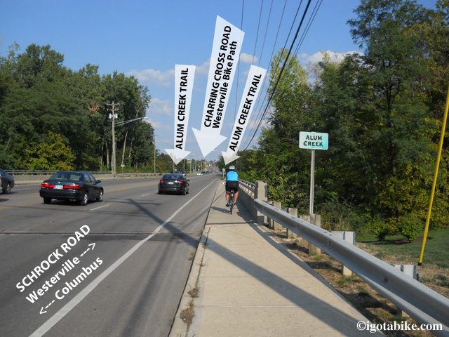
There is access to the Alum Creek Trail from both sides of Schrock Road at the bridge that crosses Alum Creek. The Westerville Bike Trail terminus is just ahead, uphill at the intersection of Charring Cross and Schrock Road.
There is access to the Alum Creek Trail from both sides of Schrock Road at the bridge that crosses Alum Creek. The Westerville Bike Trail terminus is just ahead, uphill at the intersection of Charring Cross and Schrock Road.

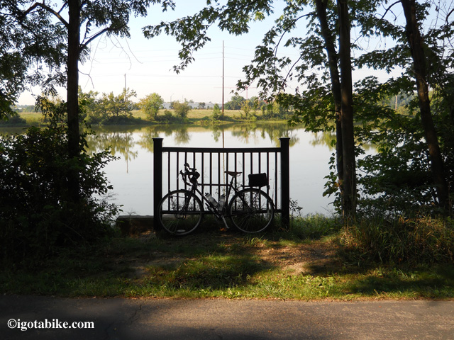
The Alum Creek Trail is nice and scenic and passes by a Lake. Guy’s Trek 520 is the perfect bike for exploring The Alum Creek Trail and the route through Columbus—even without panniers!

The Alum Creek Trail is nice and scenic and passes by a Lake. Guy’s Trek 520 is the perfect bike for exploring The Alum Creek Trail and the route through Columbus—even without panniers!

You will wind through the woods past a lake and along a pasture and will come to a bridge where the trail continues forward to Main Street or turns right to go under the bridge.
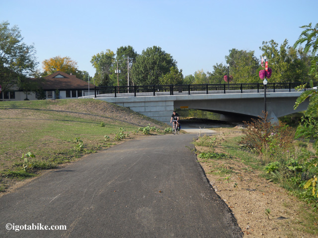
This photo shows the Main Street bridge with a bike trail going under the bridge where it dead ends into the parking lot behind the Senior Center. Stay up on top and go forward on the bike bath (out of view, left) up to Main Street to turn left.

This photo shows the Main Street bridge with a bike trail going under the bridge where it dead ends into the parking lot behind the Senior Center. Stay up on top and go forward on the bike bath (out of view, left) up to Main Street to turn left.

Go forward to Main Street and turn left on the trail, facing traffic and go down to the crosswalk to cross Main Street in front of the Westerville Senior Center. Follow the trail past a 911 Monument and in front of the Westerville fire department.
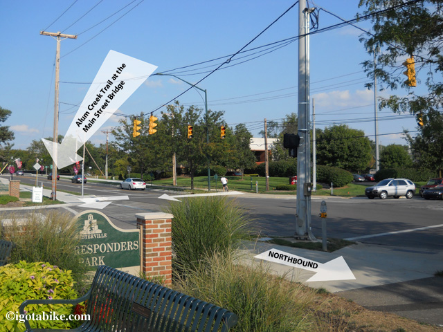
The Alum Creek Trail crosses Main Street in front of the Westerville Senior Center. Follow the trail past First Responders Park and the Westerville fire department.

The Alum Creek Trail crosses Main Street in front of the Westerville Senior Center. Follow the trail past First Responders Park and the Westerville fire department. This view is looking south.

Just beyond the Westerville fire department the bike trail picks up again and the trail is separated from vehicles by bricks as you enter Heritage Park.
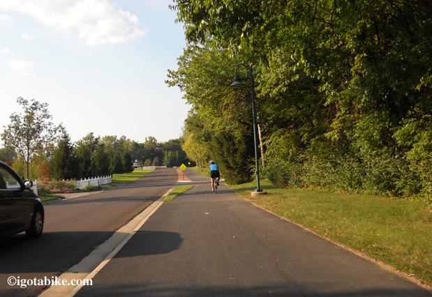
Just beyond the Westerville fire department the bike trail picks up again and the trail is separated from vehicles by bricks as you enter Heritage Park.

The trail is separated from vehicles by bricks as you enter Heritage Park.

Pick up the brick lined bike path that heads into the woods. In 1000 feet you will turn left at the balusters and exit Heritage Park.
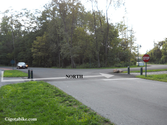
After a short distance along the brick lined path you need to cross the street at the bollisters to exit Heritage Park and go toward Cleveland Avenue. If you miss this turn the bike trail goes into the park and makes a loop. There was no sign when we were there but there is a green 4 X 4 post.

After a short distance along the brick lined path you need to cross the street at the bollisters to exit Heritage Park and go toward Cleveland Avenue. If you miss this turn the bike trail goes into the park and makes a loop. There was no sign when we were there but there is a green 4 X 4 post.

At Cleveland Avenue turn right to cross over the river on the bike path bridge that parallels Cleveland Avenue on the east side of the street. There are connector trails that take you under the bridge to a giant sports complex that you will see ahead of you on the left. You want to go over the bridge.
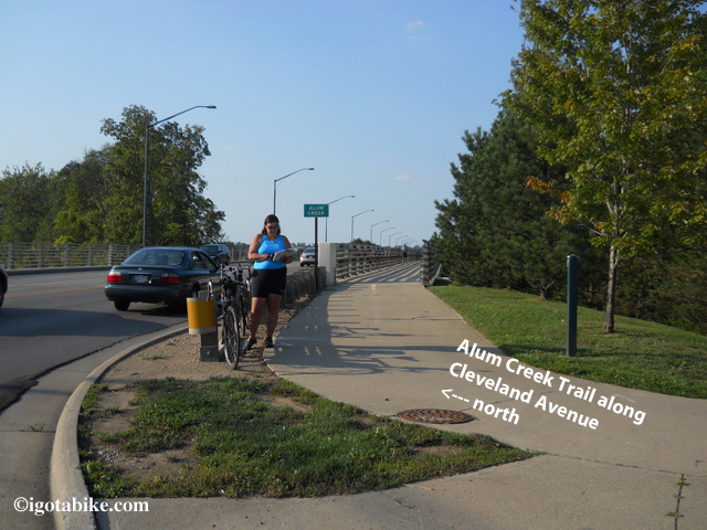
After exiting Heritage Park turn right to cross over the river on the bike path bridge that paralells Cleveland Avenue.
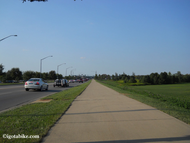
After exiting Heritage Park turn right to cross over the river on the bike path bridge that paralells Cleveland Avenue.

Continue north on the concrete bike trail on the east side of Cleveland Avenue.

Continue north on the concrete bike trail on the east side of Cleveland Avenue.

Follow the concrete bike path north and turn right on the bike path at the intersection of Cleveland Avenue and Polaris Parkway which turns into Maxtown Road.
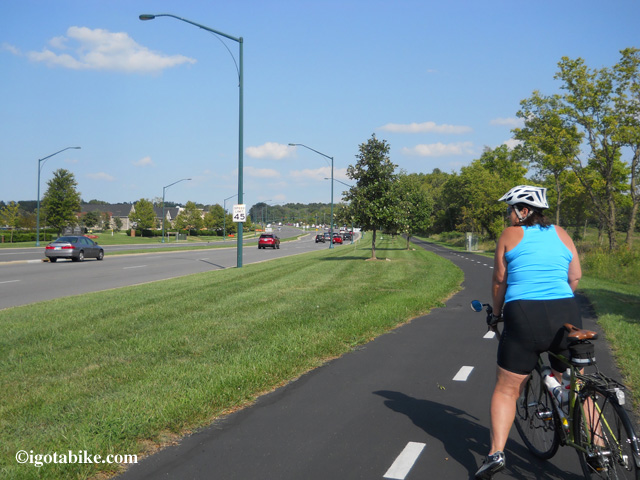
The bike trail on the south side of Maxtown Road / Polaris Parkway which connects to the Alum Creek Trail via Cleveland Avenue.

The bike trail on the south side of Maxtown Road / Polaris Parkway which connects to the Alum Creek Trail via Cleveland Avenue.

To continue north cross Maxtown Road near the entrance of Home Depot and turn right on the path, facing traffic, for 200 feet and follow the trail when it turns left to go behind Home Depot.
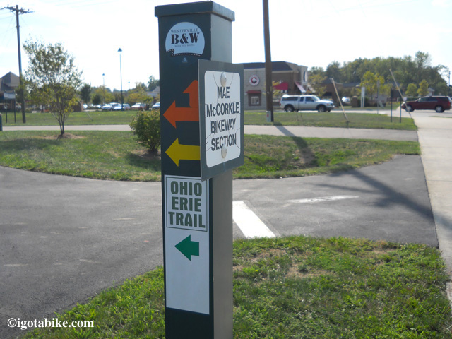
The bike trail north crosses Maxtown Road near the entrance of Home Depot. There is a sign that markes the crossing. This is the spot where the Westerville Bike Path and The Alum Creek connector bike trail meet.

The bike trail north crosses Maxtown Road near the entrance of Home Depot. There is a sign that markes the crossing. This is the spot where the Westerville Bike Path and The Alum Creek connector bike trail meet.

You will pass behind the Trek store and they provide free air and water to cyclist at their back door. Continue on this trail where it turns right at the UDF and heads into the treeline and follows Old Route 3 along the Hoover Reservoir and continues north to Cleveland.

WESTERVILLE BIKE TRAIL:
Continue on Schrock Road and cross over Alum Creek and the Alum Creek bike trail and proceed uphill a short distance to the traffic light and turn left onto Charred Cross Road. (note that on the other side of Schrock Road Charring Cross Road is called Brooksedge Blvd.)
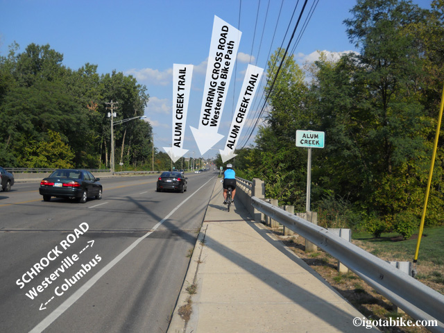
The Westerville Bike Trail terminus is at the intersection of Charring Cross and Schrock Road just beyond the Scrock Road bridge that crosses Alum Creek and the Alum Creek Trail.
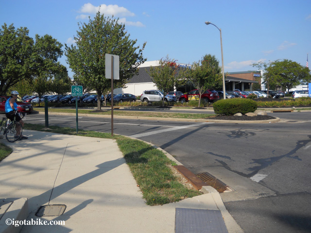
The Westerville Bike Trail terminus is at the intersection of Charring Cross and Schrock Road just beyond the Scrock Road bridge that crosses Alum Creek and the Alum Creek Trail.

Intersection of Charring Cross and Schrock Road. terminus of The Westerville Bike Trail is a few hundred feet down Charring Cross and turns right to connect to S State Street.

Intersection of Charring Cross and Schrock Road. terminus of The Westerville Bike Trail is a few hundred feet down Charring Cross and turns right to connect to S State Street.

Head down Charring Cross Road a few hundred feet and look for the bike trail on your right. This is a short connector that will take you up to S State Street where the trail turns left onto the sidewalk and appears to end. Follow the sidewalk down to the traffic light and use the cross walk to pick up the trail on the other side of State Street. There is a dedication marker for the Ohio to Erie Trail which is a brass plaque mounted on a knee high boulder. There are benches and shrubs and the trail heads into the treeline behind a Speedway gas station.
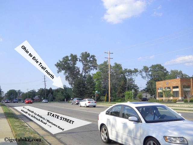
After picking up the bike trail connector from Charring Cross Road the trail appears to end. It is difficult to see that trail continues on the opposite side of S State Street.

After picking up the bike trail connector from Charring Cross Road the trail appears to end. It is difficult to see that trail continues on the opposite side of S State Street.

The trail continues north through the neighborhood and there are many road crossings–we counted seven. Many of them are small residential streets but all require a full stop as traffic is heavy in this suburban retail area. The trail continues and runs behind condos, retail complexes, past a bail field and will arrive at Maxtown Road which is also known as Polaris Parkway. To continue north cross Maxtown Road near the entrance of Home Depot. This is the spot were the Westerville Bike Path and The Alum Creek connector bike trail meet and the is an Ohio to Erie Trail sign on a green metal post. After crossing Maxtown Road turn right on the path, facing traffic, for 200 feet and follow the trail when it turns left to go behind Home Depot. You will pass behind the Trek store and they provide free air and water to cyclist at their back door. Continue on this trail where it turns right at the UDF and heads into the  treeline and follows N State Street along the Hoover Reservoir and continues north to Cleveland.
See wasn’t that easy!


Posted in Trail Maps | Tagged , , | 1 Comment

Ohio to Erie Trail North to South or South to North?

I just love to ride!

North to south or south to north, hot or cold, headwind or tailwind, I don't care. I just love to ride.

Guy and I have been getting a lot of e-mail asking us which way is better for riding the Ohio to Erie trail. Of course we suggest both is best! Ride it round trip like we did!

Guy and I both felt that the northbound route of the Ohio to Erie Trail was profoundly easier than going southbound. We often joke about going south is downhill but in this case it seemed the south to north route was more in our favor. However, our opinions may have been skewed by a few factors. . .

–It was early in the season and we were stiff and rusty especially after a no-snow winter (we cross country ski to stay fit in winter)
–trepidation
–freaky hot and humid weather (over 90 degrees in mid May)
–the pressure to arrive as planned for 3 newspaper interviews along the way

on the northbound return we were
–more in shape and road toughened
–well rested after staying at my sister’s and at the KOA
no appointments, schedules, or agendas
–much better weather though windy

I had significant fear about pedaling up Rt  62 between Brinkhaven and Killbuck but really it was not too bad. The day we did it was hot and we took our time. We tackled it at 2:00 in the afternoon hoping for a break in big truck traffic. It was much worse in my head. I also was concerned about getting into Dalton from Fredericksburg but that also turned out to be not that big of a deal. Again it was unseasonably hot but we kept a steady pace and kept eating high protein snacks at every break.

BTW The highest point on the Ohio and Erie TOWPATH Trail is just south of Akron and is 976 feet.

By far the toughest section is the southbound route on Rt 6 just south of Killbuck.
Also southbound is the section of Rt 62 between Brinkhaven and Danville that has significant hills. Last year we used the Mohican Valley Trail but if I were to do it again I would skip the trail and stay on Rt 62 and tackle the climbs.

So, for now, we prefer south to north. Perhaps we will ride it again this year and see if our opinion changes. . .
We just love to ride. I hope we get to go.

Posted in Blog | Tagged | 1 Comment

Cardboard Bicycle Helmet!

OK, this looks like something I would have made, except that I would have used duct tape for the shell :-)

The Cardboard Bicycle Helmet

Anyway, this is actually a reasonable use of cardboard, I think. All bike helmets should be discarded after a serious crash anyway. Cardboard can be very strong, yet crushable at the same time. The only problems I can see with a cardboard helmet would be with moisture- either rain or sweat. So I would think if you’re NOT prone to crashing, the foam helmet would last longer. (notice there are no vents in the plastic shell).

The benefits are touted as – lighter weight and that it actually is able to withstand THREE TIMES the impact energy of foam!

Let’s hear it for cardboard!

This would be perfect for riding the Cardboard Bicycle!

Posted in Blog | Tagged | Comments Off on Cardboard Bicycle Helmet!

First Ride of 2013 and Feeling Great

top of Hogsback Lane above the Cleveland Metroparks Rocky River Reservation

We set the camera on a guard rail and used the timer to get this shot on our first ride of 2013. We also got muddy bike shoes and muddy tires. We are at the top of Hogsback Lane above the Cleveland Metroparks Rocky River Reservation. Stinchcomb - Groth Memorial Overlook is in the background. Note Guy is wearing shorts on January 12!

We were able to ride on Saturday 1/12/13 and it was fantastic! Guy recently wrote about our effort to ride more in the colder weather in the gear section but this ride was off-topic. It was almost 60 degrees and sort of sunny and no wind! A perfect day to be on a bike in January! On the previous Saturday there was enough snow for an afternoon of cross country skiing. (which was supurb, maybe I need to start a skiing blog!)
We headed out on our routine Berea Road “maintenance ride” (6-8 miles) and ended up stretching it out to 16 miles. We left around 1:30 in the afternoon and were back by 3.
We rode into the Rocky River Reservation of the Cleveland Metroparks via Hogsback Lane which is off of Rocky River Drive (aka Riverside Drive) near McKinley Avenue in Lakewood, Ohio. This a great entrance point to the Emerald Necklace Trail which is a paved multipurpose trail that travels about 60 miles through the different reservations of the Cleveland Metroparks.
We turned north heading toward the Marina. This section of trail is nice as it leaves the road side and travels into the woods along the river. Giant sections were recently flooded and there are many trees down and other damage alongside the trail. It must have been during Hurricane Sandy. The trail itself is in good shape.
The Rocky River Reservation is beautiful and it is well-used. We saw lots of people and dogs (all smiling). Men were fishing in the swollen river and there were lots of folks cycling and jogging and even the vehicle traffic was heavy. I have never seen so many people on the trail. Everyone was enjoying the warm day. It was very nice.
The Emerald Necklace Trail is in the valley and there is always a climb to get out. The hill at the Marina is no big deal and is usually the way we exit the park. It brings you to Detroit Road on the west end of Lakewood. From this point we noodled around through the neighborhood streets working our way east. We were aiming for Franklin Avenue which is one of my favorite roads for riding (between west 150th and west 117th). There are no bike lanes and there is plenty of room for bikes in the main lane and there is a turn lane in the center so motorists can easily get around. I suppose it is so nice because there is no on-street-parking and not too many traffic lights. From here we pick up Berea Road. Its terrible getting under the railroad tracks but the rest of the way home is routine, including stopping to pick up a sandwich.
This rare day of warm weather was treat and reminds me how much I love to ride my bike. It just feels good. Head to toe, inside and out, through and through.

Posted in Blog | 1 Comment

How to Remember that Old Bike

OK.. This one is a bit weird, in a way, but we all know that bikes are art, right? I mean, you leave your bike parked in the living room just because it looks cool, dontcha?
Bicycle taxidermy.
It could also be a cool way to display other parts too. How about that ancient leather saddle, too worn to ride, but you just can,t bring yourself to throw it out?
Just a thought…

Posted in Blog | Tagged | 1 Comment

Are You Ready for a Smart Bike?

Just when you thought that the bicycle had reached the pinnacle of man-made, self=propelled machinery, it’s time to computer control it. Just add your smart phone with this app and it will shift gears for you.

Smart Bike App

In a few ways, it could be kind of cool, like automatically keeping you at a specific cadence or down shifting automatically for you when you come to a sudden stop.

Really though, one of the reasons I ride is to get away from my dang computer, so I think I’ll just stick with my old fashion machine age simplicity, thanks!

Posted in Blog | Tagged | 1 Comment

Cool New Bike Horn Sounds Like a Car Horn!

Commute a lot? You’ll dig this. It’s in the “why the heck didn’t I think of that” category. It’s a car horn for a bicycle. Check it out here Bicycle Horn

It’s a tad bit pricey, about as much as a decent headlight system, but from the video, it seems to be effective. I wonder how it would play on the bike path 😉

Personally, I’m holding out  for the diesel truck horn…

Posted in Blog, Etiquette/Safety | Tagged , | 1 Comment

Winter Riding

Winter is here, and it’s time to…

RIDE!

I know it seems like things have been slow here lately. The cold temps and lack of sunlight make it difficult to find time to ride, but this year, we have been on a mission. As far as Cleveland goes, the winter so far has been pretty mild. We have been trying not to be sissies and are trying to ride any day that it’s not raining and the temps are in the 40s. Heck, this week we were riding in the 30s. It seems like the more we do it, the higher our resistance to the cold becomes. In a lot of ways, it’s almost nicer than riding in the sweltering heat of the summer. The trick is to have the right mindset and the right clothes. As Carolyn always says,  “there’s  no such thing as bad weather, just bad clothing.” Here’s how we gear up:

At 40 degrees, the wind whistling through your helmet can give you brain freeze! So we wear a very thin knitted cap under ours. It’s pretty much a skull cap and it covers our ears, which is nice. We also have caps called Hot Noggin. They are super warm and made of neoprene and designed to go under a hard hat. They are too warm for temps in the 40s and a real concern is that, while they cover your ears, they are so dense that they greatly restrict your hearing. Dangerous for riding in traffic, for sure. We mostly use them for cross country skiing.

Our torsos are usually layered with a long sleeve wicking shirt, then one of our fleece pull overs. The pullovers have elastic at the bottom which is a nice feature. If its really cold, we can add a layer in between. A lot of times we wear a nylon jacket over the top to break the wind. Very effective.

Down below, we both usually wear bike shorts with a pair of tights over them. Sometimes Carol will add long underwear too. (cuddle duds) When it’s really cold, I’ll wear two pair of socks and Carol will wear a wool pair. I can’t find a wool pair thin enough to fit inside my road shoe, yet thick enough to be effective. I’m sure it’s just because I hate shopping.  I always pull my tights on over my socks and let them cover at least half of my foot. Both of us have booties that go over our bike shoes. If I remember right, mine are a just cheap neoprene set from Nashbar, and they really do help. It takes a little getting used to positioning them correctly on the shoes so as not to interfere with your cleats. Mine wrap around my entire shoe. I had another pair before that just pulled over the toe of the shoe, but they were always moving on the shoe and causing trouble with my cleats. The full shoe wrap is much better, IMHO. Carol’s are Pearl Izumi and just go over the toes.

For gloves we just use our regular fingerless road gloves, but we use an old, stretched out pair and we add a 99 cent pair of knit gloves underneath. Works like a charm unless it’s blisteringly cold. It still very easy to shift and brake.

Dressed like this we are good to go, and usually get back home at least a little sweaty.

Oh, don’t forget to keep your lights on your bike. We use ours for those dark and dreary days and with the sun going down so early, it’s easy to get caught out after dark.

winter riding

Posted in Our Gear | Tagged , | 1 Comment