Work around for Wolf Creek Recreation Trail (#38)
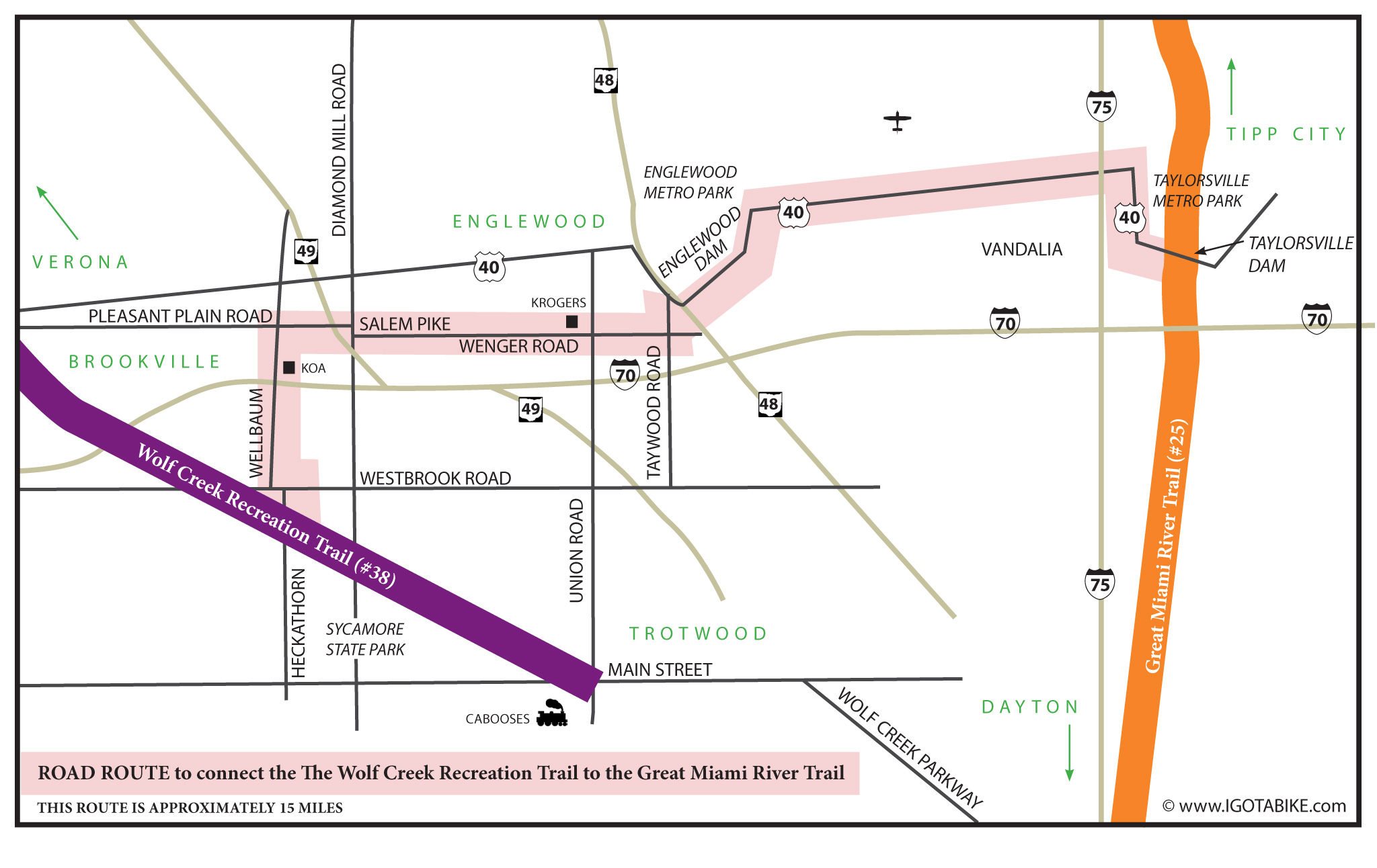
As mentioned in a previous post The Wolf Creek Recreation Trail is split in two. The west end is great, the east end, not so much. The west end of the trail takes you to bicycle riding paradise with beautiful flat back roads full of mini rolling hills and easy loops and destinations. The section of The Wolf Creek Recreation Trail between Dayton and Trotwood is not recommended. This section is a giant black eye in an otherwise excellent network of over 300 miles of bicycle trails in southwest Ohio. Instead, use the route below to connect the The Wolf Creek Recreation Trail #38 to the Great Miami River Trail #25 by using US 40. This is the route we came up with a few years ago when we discovered that the Tall Timbers KOA campground is a great bicycle destination.
Use Heckathorn and Wellbaum Road to get from The Wolf Creek Recreation Trail to get to Pleasant Plain Road to head east out of Brookville to connect with the Great Miami River Trail #25 and other Miami Valley bicycle trails. Just after crossing SR 49 there is a short dog leg–right on Diamond Mill Road–left on Salem Pike. Salem becomes Wenger Road. At Union Road there is a gigantic Kroger’s (groceries and liquor). Continue on Wenger Road and make a left turn at Taywood Road which takes you into Englewood where you pick up US 40 going east to cross over the Englewood Dam. This part is a bit tricky because you are so high up it is always windy and the road over the dam is one lane only in each direction. We have noted that motorist in this part of the state are particularly patient and courteous to cyclists so just hold your line, and watch out for the sewer grates and gaps in the pavement around each sewer to get across safely.
Continue on US 40 as it widens out to go past Dayton International Airport. Just past Peters Pike Road there is a Dairy Queen, a Friendly’s Restaurant and a gas station, all on the south side of US 40. At the intersection of US 40 and I 75 there is a Super 8 hotel, a restaurant and gas station. US 40 makes a hard right in Vandalia, then a hard left to go downhill into the Taylorsville Metro Parks. The Great Miami River Trail #25 crosses US 40 at the Taylorsville Dam. Turn left to go north to Tipp City, Troy and Piqua. Turn right to go south to Dayton RiverScape MetroPark where you can connect with the The Creekside Trail (#2) to get back to Xenia, the hub of the trails.
Click on the map to make it larger.

Follow Us on Twitter!
Follow Us on Facebook!
Pingback: Wolf Creek Recreation Trail (#38) | IGotABike
Pingback: New Route Map Connects Wolf Creek and Great Miami River Trails | IGotABike